Verification
The reliability of the methodology used to estimate runoff characteristics of developed and undeveloped areas was verified by calculating runoff from the drainage areas of Pomerado and Beeler creeks, for which actual precipitation and runoff data are available, and by comparing the measured and calculated runoff hydrographs. These creeks are tributary to Los Penasquitos Lagoon and are about 8 km. (5 mi.) east of the NCW area. Stream gauge measurements on these two creeks are available for a short period of record, so the choice of past storms that can be studied is limited.
A storm which occurred on 4 December 1972, was selected for verification. This was an isolated storm which produced fairly uniform and equal amounts of rainfall over both drainage areas. The drainage areas were divided into urbanized and nonurbanized subareas. The Pomerado Creek area is 10.6 sq. km. (4.1 sq. mi.) in size, of which about 15% is urbanized by medium-density residential housing. About 1.6 km. (1 mi.) of the creek channel is concrete-lined. Beeler Creek drainage area is 14.2 sq. km. (5.5 sq. mi.) in size and, except for a very small development, not urbanized.
The measured precipitation data from nearby rain gauging stations along with hydrologic characteristics of the subareas, estimated from soil and topographic maps and aerial photographs, were used in the HEC-1 computer program. The runoff hydrographs from each of the subareas were calculated, routed through the stream channels, and then combined to obtain the total runoff hydrograph from the drainage areas of the two creeks. These hydrographs were then compared with measured flow rates as shown in figure 1. This comparison indicates that the methodology produced reasonable estimates of runoff from Pomerado and Beeler Creek drainage areas and can be used to produce reasonable estimates of runoff for both urbanized and undeveloped areas.
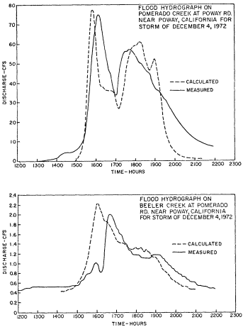
Figure 1.
Calculated and measured discharge for December 4, 1972 storm.