Past and Present Distribution of Riparian Vegetation in the Delta
The Sacramento/San Joaquin Delta is an inland triangular network of waterways formed by the rising of sea level through the Carquinez Strait between 7,000 and 11,000 years ago to meet the alluvial fans and outflows of the Sacramento, San Joaquin, Cosumnes, and Mokelumne Rivers and smaller tributary streams (Atwater 1980) (fig. 1). Both rivers and tides have shaped the land and soils of the Delta (fig. 2). Peat soils derived from tule marshes occupy most of the level, low-lying central part of the Delta. Mineral-rich alluvial soils deposited by the rivers entering the Delta predominate on the periphery. Low natural alluvial levees defined the water courses throughout much of the Delta prior to reclamation, but today only vestiges of natural levees remain, the more massive man-made levee system having obscured these natural levees long ago.
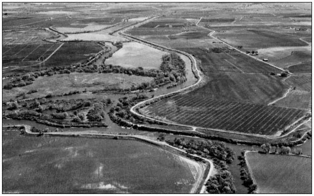
Figure 2.
The majority of Delta islands have been cut off from floods and
tides. A few channel islands continue to be influenced by both.
Before reclamation, three-fifths of the Delta was awash with an ordinary tide, largely submerged by a spring tide and capable of being entirely overflowed by a river flood (Thompson 1957). There was little topographic relief, especially in the central and western Delta. The only features rising above the sea level swamp were the typical asymmetrical natural levees, narrow ridges of alluvium meandering into the backswamps, and occasional wind-deposited hummocks of sand, the highest of these 5 m. (17 ft.) in the western Delta near Knightsen-Oakley. Most features in the central Delta were less than 3 m. (10 ft.) high.
The prereclamation Delta "islands" were thus nothing more or less than backswamps partially or fully enclosed by alluvial levees, drained by meandering sloughs. The natural levees, both parallel and lateral to waterways, were composed of fine to sandy material carried in from surrounding Central Valley uplands by the rivers and their tributaries. The Sacramento River, with its greater volume and velocity, carried greater amounts of sediment toward the Delta than did the San Joaquin, and thus deposited more substantial natural levees.
Levee banks, shaped by tidal scour as much as by river deposition, were abrupt at the river face with the land side sloping inland, enclosing a saucer-like topography. As banks rose high enough above the mean tide level, water-tolerant
vegetation could become established, checking the velocity of sediment-laden water. This would promote the accumulation of greater amounts of alluvium, encouraging more plant growth.
Generally, the height and breadth of natural levees increased with distance north, east, and south from the low tide, low water level at the western apex of the Delta. Thompson (ibid .) reconstructs an approximate gradient of increasing levee height northwest of Sherman Island, north of Isleton, north and east of Staten and Tyler Island, south and east of Roberts and Rough-and-Ready Islands, and southwest of the latitude of Rough-and-Ready Island. These natural levees beyond the central Delta might be as high as 3 to 5 m. (10 to 18 ft.), with the highest approaching 7 m. (24 ft.) at Sacramento. Natural levees averaged as much as 200 m. (660 ft.) wide along the (old) Sacramento River and 120 m. (400 ft.) wide along parts of Steamboat Slough (ibid .).
Prereclamation Riparian Vegetation
Hydric to mesic vegetation reflected the local microtopography of natural levees and hummocks and peripheral gradients in the otherwise unrelieved flat, generally wet terrain. Several investigators have reconstructed historic conditions by studying early illustrations as well as the few remaining sites which are relatively pristine. Thompson describes the conditions that were seen by travelers going up the Sacramento River:
The monotony of the green or brown canebrake-like vegetation was broken by channel and pond surfaces and by strips of alluvial land where woody shrubs and trees and herbaceous annuals grew. This natural levee cover consisted of coarse bunch grasses, willows, blackberry, and wild rose thickets, and galleries of oak, sycamore, alder, walnut, and cottonwood.
The shrubs appeared among the tules of Sherman, Lower Roberts, and other centrally located islands, but a continuity of woody growth probably did not develop until the latitude of Brannan Island and Stockton. This cover became a belt of heavy oak timber on the upper four miles of Union Island, and probably on Robert's Island. Fine groves occupied the more southerly San Joaquin distributary banks. Similar stands of woods occupied the Sacramento River levees upstream from about the lower end of Grand Island, in places so overhanging the river that it interferred with the rigging of passing ships (ibid .).
Levees and Reclamation
Levee building and reclamation of Delta lands irreversibly altered the physical appearance and function of the area. Perhaps nowhere in California have changes to the physiography and hydrography of an area been as profound as those that accompanied reclamation within the Delta. At the same time, throughout the major and minor drainages which feed into the Delta, major land-use changes significantly altered fluvial processes of erosion and deposition, ultimately affecting Delta waterways.
The history and techniques of levee construction in the Delta have been thoroughly documented and need only be reviewed briefly here. The early "shoestring" levees were handbuilt from blocks of sod from island interiors; they were low earthen mounds, resembling natural alluvial levees, and afforded little protection from flooding. Later, clamshell dredges constructed higher, more substantial levees, using construction material from "borrow" ditches immediately external to the levee site. This practice created levees that were set back from an outer, waterside berm. When it was realized that levee survival was partly predicated on the flood-carrying capacity of adjacent channels, the interval between levee toe and borrow ditch was broadened. These residual berms also helped protect levees from rupture and wave attack (ibid .).
To some extent, the berm could accommodate a natural riverine system, the channel and narrow floodplain between levee and berm becoming part of a complementary system in which overland flow could be regarded as a natural process rather than an unnatural hazard. As levee construction techniques improved and conditions of channel alluviation and interior island subsidence dictated, artificial levees became more massive, as much as 61 m. (200 ft.) broad at the base and 9 m. (30 ft.) high, dominating the landscape. Natural levees and most of the artificial berms have either been removed in channel or levee improvements, concealed by reconstruction, or eroded away. The large levee structures which replaced them are so sloped and elevated above the natural floodplain level that with or without riprap they have lost the appearance of a natural floodplain and "riparian zone," except for obvious proximity to a waterway. Nevertheless, the levees introduced into the Delta many miles of topographic relief.
To the extent that "riparian" is an adjective that defines the topographic zone adjacent to fresh water (Warner 1979), the 1,600+ km. (1,000+ mi.) of man-made levees that now line 1,120 km. (700 mi.) of Delta channels and sloughs are riparian zones and hence existing and candidate substrates for woody riparian vegetation. The actual extent of this linear zone probably exceeds that of the prereclamation natural alluvial levees, particularly in the central Delta, which was largely a tidal marsh with little topographic variation.
"Riparian" as a concept also embraces other attributes—notably available soil moisture (high
groundwater table), even distant from waterways. As reclamation proceeded, the backswamps of the Delta were drained and levees cut off their replenishment by flooding. But the water table has continued to be at or near the surface of the land, which is 3 to 6 m. (10 to 20 ft.) below mean sea level in many areas. These conditions would enable mesic vegetation to invade most of the Delta if the land were not regularly drained, cleared, and cultivated.
Changes to Riparian Vegetation Since Reclamation
It is ironic that humans—having built into the unrelieved flat landscape of the Delta hundreds of miles of "riparian zone" within or above the normal tide and floodplain level, sufficiently elevated to support luxuriant plant growth, and having drained the swamps—have been stripping, burning, plowing, or covering much of it ever since.
Some of the early land developers planted alfalfa or Bermuda grass on the waterside of levees in an attempt to reduce wave damage. Willows were used more commonly because they survived prolonged submersion better than alfalfa. Some reclamation interests thought that the roots of willow and other shrubs would reduce the tendency of peat levees to burst when subjected to prolonged river pressure. Unfortunately, willows tended to choke out the tule, depriving levee faces of the mass of sod and stems which were thought to break the force of wave action.
The protective role of berms left in early levee construction was enhanced by natural invasion of willow, cottonwood, and tule, which formed a living defense against wave attack. The exterior borrow ditches served as alluvium traps and sites for succession from tule marsh to diverse riparian communities. Most of these berms are now gone; those remaining are restricted largely to a few reaches where setback levees have been deliberately reconstructed.
Since reclamation, the areal extent of all types of vegetation in the Delta has been steadily decreasing, becoming limited to narrow waterway margins and the outer edges of some levees, a few overflowed tracts, small unreclaimed islands and undeveloped lands outside levees, trapped sloughs and drainage ditches, some inner levee slopes, and whatever lands in island interiors have been left uncultivated or used as dredge spoil sites.
The Delta still contains remnant stands of riparian forest which, if they survived initial reclamation and subsequent clearing of land, continue to survive in spite of virtual isolation from the fluvial processes which induced and once sustained them (fig. 3). A few significant stands of riparian woodland can be found on the periphery of the Delta; there are examples near Thornton at the confluence of the Cosumnes and Mokelumne Rivers, isolated stands northwest of Stockton, and along the southern reaches of old Sacramento River and the San Joaquin River south of Stockton and Tracy. Other vestiges still exist on wooded islands, on a few remaining unleveed banks, and on occasional broad berms left on the waterside of levees.
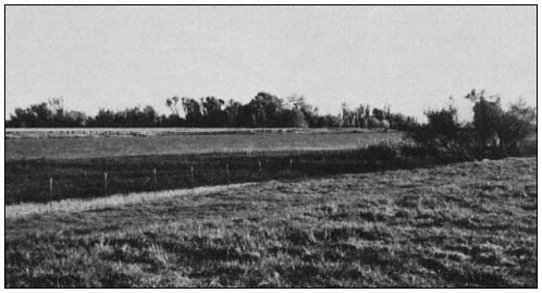
Figure 3.
Most stands of riparian forest have been cleared from the Delta floodplain, leaving stringers
or small islands of cottonwood and associated species in a few uncultivated areas.
Much of the adventitious riparian growth in the Delta still reveals itself as a series of hydric and mesic communities only partially
related to the dynamics of the waterways, dominated by emergent marsh species, with hummocks, older levees, highly modified levees, and miscellaneous interior areas supporting shrub thickets of woody and weedy species. The persistence of certain mesic species in springing up where ever the presence of groundwater, seasonal flooding, and benign neglect permit, is evidence of the natural propensity of the Delta to support riparian plant growth.
"Surrogate" Riparian Communities in the Delta
It is unlikely that levee construction and maintenance, with flood control as its main objective, and the prevailing agricultural land use, which is totally dependent on the levee system, will ever permit further manifestation in the Delta of the rich diversity of species and complex physiognomy that characterize a fully developed riparian plant association. Significant political, economic, technical, legal, and philosophical questions revolve around the maintenance of that system. Two perennial considerations that constrain riparian vegetation in the Delta are: 1) the degree to which vegetation on levees ("riparian" because of the obvious proximity of levees to waterways) is compatible with the primary flood control function and design specifications of the levee system; and 2) the degree to which "natural" vegetation in island interiors ("riparian" because of persistent high groundwater) is compatible with intensive crop cultivation. The levee and other riparian and quasiriparian communities now found in the Delta are often natural in appearance but nonetheless are largely dependent on deliberate or inadvertent human actions.
Levee Riparian Vegetation
The four most common riparian-like communinities associated with waterways on Delta levees are shrub-brush (scrub/shrub in the Sacramento/San Joaquin Environmental Atlas (US Army Corps of Engineers 1979)), brushy riprap (also designated scrub/shrub by the CE), herbaceous banks (labelled upland by the CE (ibid .)), and unvegetated riprap, now a common condition on most maintained and reconstructed levees. Other riparian-like communities found on levees might be called urban (landscaped) riparian; monospecific riparian with such species as willow or alder; and "discontinuous" riparian, evidenced by occasional isolated trees left standing in the wake of stripping, burning, or disking.
Riparian Shrub-Bush .—Riparian shrub-brush is characterized by broad-leaved woody growth less than 6 m. tall. The most common plants are shrubs such as blackberry, wild rose, young alder at the edge of the water, willow species, and herbaceous species such as mugwort and stinging nettle. Occasional small trees—usually willow, cottonwood, or sycamore—may be present. This is a highly variable community; if left undisturbed, as on natural berms on the margin of some of the channel islands, it would develop into woodland. Periodic disturbance from levee maintenance practices generally discourages this long-term successional process, however.
One of two structural components typical of fully developed riparian vegetation may be absent. An upper stratum such as that provided by mature cottonwoods with snags is most often absent. There may or may not be a well-developed thicket and ground stratum, depending on how negligent levee inspection and maintenance have been.
Diversity of bird use of this habitat parallels its relatively lesser vegetative diversity and structural complexity. For example, hawks (e.g., Red-tailed, Red-shouldered, and Swainson's), woodpeckers (Downy and Nuttall's), and certain warblers are heavy users of wooded riparian areas and are largely eliminated from this community by the absence of an upper tree stratum. On the other hand, there is still sufficient vegetative diversity and cover to provide useful habitat for many common species of birds and mammals.
Other variables besides species composition influence wildlife use of this community; continuity (the linear distribution) is often interrupted at property lines or by periodic or partial maintenance; adjacent habitats (agricultural, urban, aquatic) in part determine the distribution of species in and extent of their dependence on this modified riparian vegetation-type.
Brushy Riprap .—Brushy riprap, one of the more common conditions on Delta levees, is valuable as wildlife habitat where riprapped banks have not been disturbed by inspection or maintenance for several years, or where riprapping has been limited to lower portions of the levee, allowing natural vegetation to remain on the upper levee. Vegetation here is less varied than in scrub-brush. Common wild blackberries predominate; other species include occasional shrubby alders at about mean water line, stinging nettles, wild radish, willows, and smartweed. Only when the vegetative cover on riprapped banks has grown almost out of the brush stage does the habitat appear to support wildlife comparable to shrub-brush banks.
Riprap which is exposed at low tides precludes bank burrowing by beavers, muskrats, and kingfishers. Hawks, woodpeckers, most warblers, and flycatchers are eliminated from this kind of substrate; ground foragers and swallows predominate. The yellow-throat, common on Delta freshwater marshes, uses the blackberry jungles of this community. Unvegetated, exposed riprap banks actually enhance striped and black bass habitat by providing substrate for crayfish, an important food source for bass.
Herbaceous Banks .—Herbaceous banks are most common on riprap or on banks where regular maintenance precludes all but summer annuals such
as reed grass and giant reed (at the waterline), scouring rush, blackberry, and wild oats, brome, other introduced grasses, and a variable cover of thistles, poison hemlock, with occasional willow saplings. During the fall and winter, when cover is at a minimum, wildlife use is limited. Summer growth encourages use of the habitat by small seed-eating birds. The only bird species whose presence would qualify this as distinctively "riparian" are the Belted Kingfisher, which perches on small structures associated with the grassy banks, and the swallows flying low overhead. The most conspicuous inhabitant of herbaceous banks in spring and summer months is the ground squirrel, whose potentially destructive burrow colonies are actually favored by cutting and burning of vegetation to facilitate visual inspection of levees (John Muir Institute 1978 a,b).
Unvegetated Riprap .—Unvegetated riprap is similar to herbaceous banks in its absence of vegetative cover. At most, the habitat offers perches and resting areas for birds using the open water and nearby brushy areas.
Neither unvegetated riprap nor herbaceous banks can really be considered "riparian" except according to a broad topographic definition of the term. Yet the majority of levees lining Delta waterways are being managed to achieve this result (fig. 4). A variety of intermediate conditions exist throughout the Delta: old riprapped banks on which willow has formed a discontinuous cover; partially neglected levee faces on which alder saplings have sprung up at the waterline; miles of giant reed lining the water's edge on grass-covered levee banks; occasional trees left to stand alone because the surrounding bare levee slopes permit visual inspection of otherwise pernicious root systems; landscaped residential and recreational frontages, notably deficient (for habitat purposes) in ground or brush stratum or liana. Each of these provides a limited habitat resource, always enhanced by the proximity of water and offering in return at least a narrow, if discontinuous, margin of vegetation or substrate to complement the aquatic environment.
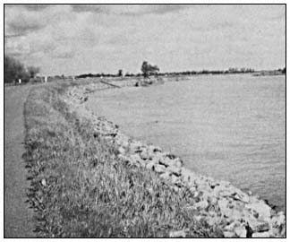
Figure 4.
The safest levee from the perspective of flood control managers
is free of vegetation and open to visual inspection. Habitat
resources are virtually eliminated.
Interior Riparian Vegetation
The most extensive remnants of native riparian woodland occur around the outer margins of the Delta, along those portions of natural floodplains which were either not leveed or not cleared for agricultural cultivation. In a few locations, woodlands extend well back from the rivers along with the alluvial soils on which they grow. Where alluvial soils still exist as narrow levees or margins bordering peat lands in the central Delta, riparian woodlands are minimal and display less deversity of species and structure. Small riparian woodlands occur in the interiors of small islands or on island tips which were all or partially leveed during dredging operations but never cultivated.
The Sacramento/San Joaquin Delta Wildlife Habitat Protection and Restoration Plan (California Department of Fish and Game 1980) did not limit its survey to more obvious manifestations of riparian vegetation on levees along waterways and on the periphery of the Delta. Even highly modified island interiors can reveal wildlife habitats with riparian characteristics. These include seasonally fallow or ruderal lands, dredge disposal areas, drainages and irrigation ditches, and seasonally or periodically flooded agricultural lands.
Ruderal Lands .—Ruderal lands are not widespread in the Delta, where most available land is cultivated. However, a few long-untended fields, abandoned homesites, and agricultural lands damaged by sandy sediments of past floods (e.g., a portion of Brannan Island following the 1972 flood) have been allowed to revert to an almost natural state and are characteristically early successional communities. Species such as sandbar willow, Goodding's willow, and arroyo willow and thick tangles of blackberry are evidence of sufficient year-round soil moisture to eventually support a more diverse riparian-like community behind the levees. Even narrow brushy margins between cultivated fields become important wildlife corridors or islands in the predominantly cultivated landscape.
Unfortunately, ruderal lands in the Delta are totally dependent on individual farming practices. These areas must presently be regarded as transitory, subject to burning, plowing, crop changes, and "clean" farming. They are heavily used by mammalian predators and raptorial birds such as White-tailed Kites and Short-eared Owls because they support large populations of prey species—rodents, reptiles, and ground birds.
Dredge disposal sites .—In the Delta these areas resemble ruderal lands in that they support early successional communities and are highly variable, depending on the underlying residual vegetation, depth of spoils, elevation, and recency and frequency of deposition. Vegetation varies particularly with the age of the spoils; it is not uncommon to find older areas supporting young willows and cottonwoods, as well as herbaceous and other woody species. As with ruderal lands, year-round soil moisture is probably sufficient to eventually sustain larger riparian species if disturbances were discontinued (fig. 5).
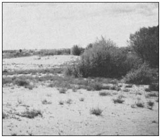
Figure 5.
Dredge material disposal sites in the Delta have
demonstrated the ability to support adventitious
riparian species, such as willow and cottonwood.
Drainage and irrigation ditches .—Drainage and irrigation ditches border and criss-cross agricultural fields and levees throughout the Delta. A few major ditches, such as the one which parallels 8-Mile Road northeast of Stockton, have well-established woody species such as willows and cottonwoods along their banks; others are little more than strips of tules and cattails with brushy margins. While these might be considered minimally "riparian", they are so numerous and widespread that they contribute a significant amount of aquatic and bankside wildlife habitat to the Delta, especially for common birds and amphibians.
The most useful agricultural wildlife habitats in the Delta, and the most "riparian-like", are fields of corn and grain stubble, flooded for several months during the winter for leaching or to create waterfowl habitat. These fields support far greater numbers of individuals (although fewer species) than do more typical riparian areas in the Delta, and closely resemble or at least substitute for ancestral wetland which, prior to reclamation, supported many thousands of the waterfowl wintering in the Delta and elsewhere in the Central Valley. Whistling Swan, Canada Goose, and Sandhill Crane in particular are dependent upon partially flooded fields for winter feeding and resting habitat.
Some fields are flooded briefly in late summer and early fall to control weeds and centipedes. These fields also provide temporary habitat for migrating geese, swans, ducks, and shorebirds. The number, area, and location of flooded fields in the Delta vary considerably from year to year, depending on weather and current leaching practices.